Navigation path
- EC
- Copernicus
- Emergencies
- Droughts
- EDO
- EDO Home


The activities of the Drought Team responsible for the European and Global Drought Observatories are part of the series of activities in the JRC on which you can find more on these pages: View the projects >
Search different types of resources (maps, data, papers, services) providing information about drought
•••••••••••
 Welcome to the European Drought Observatory!
On Wednesday 3 April 2024 at 9:00 CET, EDO and GDO have been moved to a new Internet domain that is part of the Copernicus Emergency Management Service (CEMS) main domain, being EDO and GDOe than 5 years key part of the Copernicus programme. This domain change will help you to get a better overview of all the information, data, and services provided by the Copernicus programme and make easier to switch from one to the other.
The domain change is automated for a year, but please update your bookmarks as soon as possible!
Welcome to drought.emergency.copernicus.eu!
The domain change is automated for a year, but please update your bookmarks as soon as possible!
Welcome to drought.emergency.copernicus.eu!
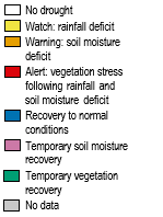
The EDO pages contain drought-relevant information such as maps of indicators derived from different data sources (e.g., precipitation measurements, satellite measurements, modelled soil moisture content).
Different tools, like Compare Layers, allow for displaying and analysing the information and drought reports give an overview of the situation in case of imminent droughts.
You can download most drought data used in the European and Global Drought Observatories following this link.-->
According to the latest map of the Combined Drought Indicator 14.7% of the EU-27 territory (without Madeira, Azores, Canary Islands) plus the United Kingdom is in Warning conditions and 1% is in Alert conditions | |